Explore the Ozarks · Northwest Arkansas
Beaver Lake: History, Geography & Facts
Beaver Lake is a reservoir on the upper White River in Northwest Arkansas. Beaver Dam made the lake possible, but the Ozarks gave it its shape. The wooded coves and rock bluffs you see from the water follow a landscape that was here long before the dam.

Beaver Lake’s rocky shoreline seen from the water.
Beaver Lake at a glance
Beaver Dam construction
1960 – 1966
Estimated mean depth at conservation pool
~ 59 feet
As the crow flies - the dam to start of the lake
~ 50 miles
Acreage and shoreline figures are from the 2018 USGS survey at the conservation pool, a reference elevation for the reservoir. Mean depth is calculated from the same USGS area and storage figures. The deep-basin figure comes from a published Beaver Lake study. Depth changes with the reservoir level, and published estimates of maximum depth vary.
Water surface
~ 27,900 acres
Deep basin, reported in a lake study
~ 200 feet
Old channel of the White River
~ 73 miles
Shoreline
~ 449 miles
Storage at conservation pool
~ 534 billion gallons
Distance on water: Dam to Hogscald Hollow
~ 13 miles
How Beaver Lake was created
Congress authorized the project through the Flood Control Act of 1954. The reservoir began filling in December 1963, commercial power generation began in May 1965, and the dam was completed in June 1966. The lake first reached its conservation pool in 1968. Beaver is the uppermost of the major federal reservoirs on the White River main stem.
What was here before the lake?
Before the lake, the White River wound past farms, roads and small communities. Families moved and graves were relocated ahead of the rising water. Places such as Glade and Pine Log were part of the wider story of that valley. The old landscape survives in scattered traces, including roads and foundations.
Rising water also covered much of Monte Ne, the resort built by William “Coin” Harvey. Parts of its amphitheater have been visible at very low lake levels.
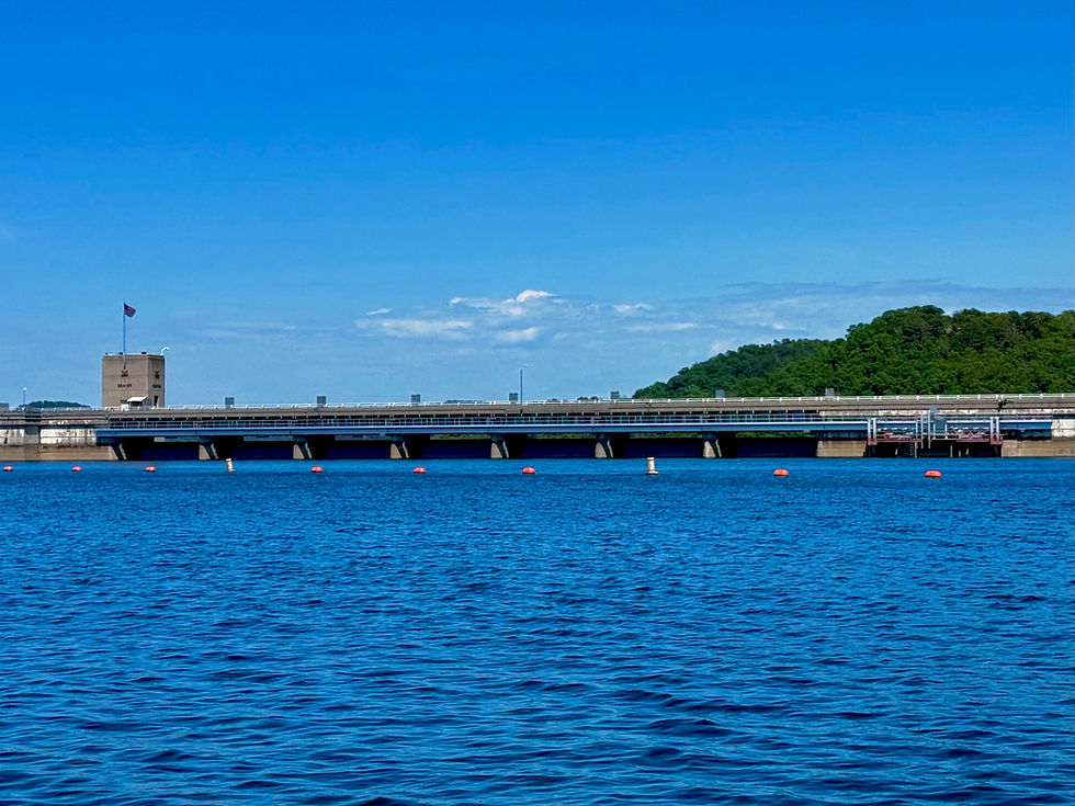
Beaver Dam from the lake side.
How deep is Beaver Lake, and why do the numbers vary?
The lake is shallow along many shelves and flats and much deeper in the lower basin toward Beaver Dam. The 2018 USGS survey estimates about 1.64 million acre-feet of water over 27,900 acres at conservation pool. Dividing storage by area gives a lakewide mean depth of about 59 feet. A separate research study reports a maximum of 61 meters, or about 200 feet. That figure describes the deep basin in that study and changes with lake elevation.
The Army Corps’ shoreline plan reports 28,299 surface acres and about 490 miles of shoreline at its stated conservation reference. These are separate survey figures. Water level changes the footprint of the lake, and the survey and shoreline measurement also matter when comparing published numbers.
What the lake does for Northwest Arkansas
Beaver Lake stores floodwater, supplies drinking water, supports hydropower and provides habitat and recreation. The Beaver Water District draws from the lake and supplies treated water to Fayetteville, Springdale, Rogers and Bentonville for distribution. Water storage changes with inflow, withdrawals and releases, which is why a storage figure is most useful when it comes with a reference elevation.
Why Beaver Lake is warmer at the surface
Sunlight warms the upper water in summer. That warmer, less dense water stays above cooler, denser water in the deeper basin. Between the two is the thermocline, where temperature drops quickly with depth. The depth of that transition can shift with weather, season and location, so the temperature beside the boat tells you only about the water near the surface.
Beaver Lake surface vs. bottom temperatures
SEASON
SURFACE
BOTTOM
Summer
78–90 °F (25.6–32.2 °C)
39–45 °F (3.9–7.2 °C)
Winter
32–45 °F (0–7.2 °C)
37–40 °F (2.8–4.4 °C)
Seasonal ranges published in the Beaver Water District watershed guide. These describe a range of conditions across each season. Individual readings vary by site, date and depth.
SURFACE
BOTTOM
What happens when the lake turns over?
Summer layers form
Warm surface water sits above colder deep water. The layers mix less readily.
Fall cooling weakens the layers
The surface cools and gets closer in density to the water below. Wind can mix the water deeper.
Winter mixing reaches deeper water
The difference between surface and bottom temperatures narrows. Mixing can carry oxygen deeper into the lake.
Turnover is a seasonal process. USGS describes Beaver Lake as a reservoir with summer and fall layering and one period of complete mixing, in winter. Timing depends on cooling, wind and conditions across the lake.
What temperature and oxygen mean for fishing
Fish need a workable combination of temperature, dissolved oxygen, food and cover. In summer, oxygen in deep water can decline as organic matter breaks down and the layers exchange less water. Cool water can therefore be poor habitat if there’s too little oxygen. As the water mixes later in the year, the depths with suitable oxygen and temperature can change, along with where fish and the baitfish they follow are found.
Beaver Lake anglers pursue largemouth, smallmouth and spotted bass, striped bass, crappie, walleye, catfish and sunfish. For example, a striper angler looking for cooler water also needs to consider oxygen and where shad are holding. A bass angler working a rocky point may focus more on cover and forage. The thermocline is one clue about where to start looking.
Why there are trout below Beaver Dam
Water released from deep in Beaver Lake helps create the colder Beaver Tailwater on the White River. Arkansas Game and Fish Commission began stocking rainbow trout there in 1966 after the dam changed the river’s habitat. Norfork National Fish Hatchery is one part of the stocking story. Its federal program raises trout for tailwaters including Beaver.
Our guided fishing trips take you to the White River tailwater below Beaver Dam. Our scenic cruises explore Beaver Lake above the dam.
The Big Clifty Arm near Eureka Springs
Big Clifty is the part of Beaver Lake we spend much of our time exploring on Day Trippin cruises. The shoreline folds into smaller coves and hollows, including Hogscald Hollow, Penitentiary Hollow and Pemberton Hollow. As you round a point, look for the horizontal rock layers, shallow shelves and waterfall ledges along the waterline.
The arm takes its name from Big Clifty Creek. The name fits the steep, cliff-lined terrain. The origin of the creek’s name is less certain.
Why the bluffs and coves look this way

Horizontal rock layers and a waterfall ledge along a Beaver Lake cove.
The Ozark Plateaus contain layers of limestone, dolostone, chert, sandstone and shale. Streams cut valleys through these layers. Slightly acidic groundwater can also dissolve limestone and dolostone along cracks, helping form caves, springs and sinkholes. The rising reservoir flooded the lower parts of the old valleys. From the water you can still see their shape in the long arms, narrow hollows and bluff walls.
Big Clifty Park
Big Clifty Park is one place to get on the water near Eureka Springs. It’s one of our meeting spots for kayak rentals. Your booking details tell you where to meet.
Wildlife you can watch from the water
Look for great blue herons along shallow edges, kingfishers near the waterline and turkey vultures circling above the bluffs. The wooded shoreline gives white-tailed deer and wild turkeys cover. You may spot deer near the water or see signs of beaver activity along the bank. River otters occur in Arkansas waterways and are more elusive.
Bald eagles at Beaver Lake
Beaver Lake attracts wintering bald eagles and supports breeding pairs. Open water gives them a place to look for fish, and mature trees along the shoreline offer perches and nesting habitat. We’ve spotted bald eagles perched in shoreline trees in Hogscald Hollow, one of the coves we often explore on Big Clifty cruises. A sighting is one reason to bring binoculars. Give nesting birds room and watch from a distance.

A great blue heron watching the water from a low branch.
Check lake levels before you go
Rain, drought and dam releases can change the lake level. The Army Corps uses conservation and flood pools as operating references, and its lake report shows the current elevation alongside those references. A change in water level can reveal rock shelves or cover them and change conditions at a launch ramp. Waterfall flow varies with rainfall.

See Beaver Lake from the water
Come out with Day Trippin Eureka Springs for a private scenic cruise, or rent a kayak and explore at your own pace.
Looking across Beaver Lake from the Day Trippin pontoon.